Scene
A Beginner’s Guide to Tornado Safety
Was “Twisters” (2024) a decent movie? Maybe. Out of the three movies about tornadoes that I can think of, it’s not nearly as good as the original “Twister” (1996), and nobody can beat out the truly incredible cinematic feat that was “Sharknado” (2013). I don’t think the “Twisters” target audience includes tornado know-it-all Oklahomans like my family and I who spent most of the runtime pointing at the screen and whispering, “Actually, that would never happen,” though, so I’m not sure I get to have an opinion.
Clearly I don’t know much about what makes a good disaster film, but I have spent my entire life living in Tornado Alley (a zone in the Central United States where tornadoes occur most frequently), so I do know quite a bit about real tornadoes. Coming to WashU, I wasn’t too concerned about the tornado threat here in St. Louis — they were scary, sure, but they were also nothing new. It never occurred to me that many people had not experienced tornadoes until a tornado warning was issued during my first semester here back in late 2024, and all I heard about over the next few days were complaints about “fake” tornado warnings and how annoying the WashU alerts were.
Not everyone is from Tornado Alley, though, and I’d be just as oblivious as everyone else if I was experiencing my first tornado in college of all places. As we go into this spring’s storm season, it’s important to be prepared. So, for all of you non-Tornado Alley dwelling students out there, I present to you: a beginner’s guide to tornado safety.
Myth: Tornadoes are easy to spot.
Truth: If you ask the average person what a tornado looks like, they’ll usually describe a long funnel with a large cloud of dust surrounding the bottom of it. While some tornadoes might look like this — formally known as cone tornadoes — the truth is that there are many different types of tornadoes, including some clouds that look like tornadoes even though they’re technically harmless. For example, chances are you’ve probably seen a phenomenon called scud clouds, which are wispy, low-hanging clouds that sometimes form funnel-like shapes. This can make them easy to mistake for tornadoes by casual observers. Additionally, real tornadoes might be rain-wrapped (completely obscured from view by heavy rain) or occur at nighttime, making them difficult to spot.
Even if you can’t identify a tornado, there are warning signs to keep an eye out for. During the day, skies will sometimes look yellow, green, or unusually dark before a tornado or hailstorm. Just be sure not to confuse this with the warmer orange hues that tend to follow after a thunderstorm rolls through in the early evening. Many people describe hearing a roaring sound and feeling their ears pop as a tornado approaches, especially if it’s close by. However, you should never rely on these signs as your main form of warning. Pay attention to National Weather Service (NWS) weather alerts and pull up a local news channel such as KMOV Channel 4 or KSDK Channel 5 on your phone if you can — you can usually watch these for free by going to their websites, and they often dedicate large portions of their airtime to the weather during severe storm events. Most cell phones also automatically receive tornado warnings through the national Wireless Emergency Alerts system, which sends notifications during life-threatening events. For WashU-specific coverage, the WashU Weather Team provides updates on Instagram (@washuweather) during severe weather events, and WashU Emergency Management (@washuready on Instagram) handles the WashU Alert system.
Myth: You should keep your windows open during a tornado to equalize pressure.
Truth: I am begging you not to do this. I don’t know if this is all that common anymore, but it used to be, and the only thing leaving your windows open is going to do is let debris in. Also, if you can see windows at all during a tornado event, you’re probably not in the right place.
Assuming you’re inside of a building — and if you’re not, find one! — the best place you can be is a basement or severe weather shelter. Given that these aren’t always readily available, though, your next best option is an interior room or a space completely removed from all exterior walls and windows on the ground floor of the building. Ideally, this room will have some kind of sturdy furniture to shelter beneath, such as a heavy table. Distance yourself from objects like bookshelves and large drawers, as these can pose a tip-over hazard if left unanchored to the wall. In WashU buildings, locate a building map near the exits or elevators to help you locate a Severe Weather Refuge Area (SWRA), which are typically interior hallways. If you’re in a house or apartment, the most interior room will generally be a bathroom (and, if one is available, inside the bathtub), closet, or pantry. Keep essentials with you as well, including your shoes, keys, and phone. Get as low as possible and cover your head with your arms, and protect yourself from falling debris with blankets and pillows.
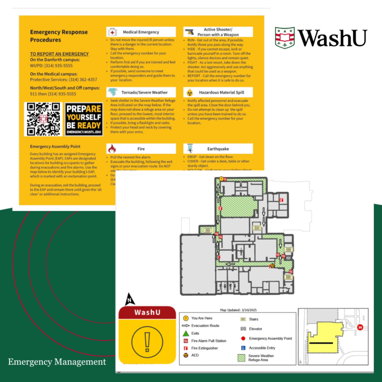
Courtesy of WashU Emergency Management
Myth: If you’re driving when a tornado touches down, seek an overpass for shelter.
Truth: The most famous endorsement of the overpass myth, as it’s now known, came from a broadcast shot by a Kansas television crew during the 1991 Great Plains tornado outbreak. This myth was decisively debunked in 1999, when three people were killed in Oklahoma after being swept out from under overpasses in three separate incidents. (Speaking of “Twisters,” this happens in the opening scene of the film as well.) Without straying too far into physics territory, winds move faster when they’re suddenly constricted, including beneath overpasses. This makes overpasses one of the most dangerous places you can be during a tornado. The same goes for parking beneath an overpass, which can expose you to tornadic winds and make you a major traffic hazard.
That being said, attempting to outdrive the tornado should be your last resort — unless you race cars for a living, maybe, but you’re not Max Verstappen. Tornadoes can move at speeds of up to 70 miles per hour and tend to make erratic turns as they travel. If you can’t quickly drive to a building or shelter, pull over, abandon your car and lie flat in a ditch or other low-lying area while covering your head with your arms to protect yourself from debris. As is the case with hiding inside of a building, you can also protect yourself with spare blankets or cushions. It might sound counterintuitive, but a ditch will shelter you from the worst of the debris and high-speed winds, while even relatively weak tornadoes can flip your car over.
Myth: Meteorologists only issue tornado warnings when they are certain that there is a tornado on the ground.
Truth: Often, tornado warnings are issued ahead of what meteorologists anticipate will become a tornado. If you read the text product associated with a tornado warning (which can be done by going to the NWS website or using apps like Weather Channel), for example, it usually includes a line denoting whether the source for the warning was a radar indication, trained spotter sighting, or confirmed tornado. While only about 25 percent of tornado warnings precede a true tornado on average, that doesn’t mean the other 75 percent are completely unfounded. Tornadoes can spin up in seconds — it’s better to play it safe and issue a warning when circulation shows up on the radar than to get a warning out too late and put people’s lives at risk.
Aside from tornado warnings, meteorologists use other forms of weather alerts in tornado forecasting as well. One of these is called a tornado watch, which indicates that conditions may be favorable for tornadoes in the near future. These are relatively common and tend to encompass many counties (anywhere from 30 counties to upwards of 70 — in 2025, the average tornado watch event included about 50 counties) for an extended period of time, typically anywhere from four to eight hours. You might also see something called a Particularly Dangerous Situation (PDS) watch or warning: the former is issued on days when the risk of tornadoes is very high, while the latter indicates an ongoing tornado that poses a considerable threat to human life and property. (For reference, the original tornado warning during last year’s tornado was upgraded to a PDS warning once the NWS had confirmed that a strong tornado was occurring.) In very rare situations where an ongoing tornado is expected to cause catastrophic damage, the NWS will issue a tornado emergency. Only around 300 tornado emergencies have ever been issued since they were first created in 1999.
Myth: Tornadoes are measured by wind speed.
Truth: Every tornado in the United States is rated using the Enhanced Fujita (EF) Scale framework, which measures the tornado’s intensity based on the damage it produced on a scale from EF-0 (light damage) to EF-5 (incredible damage). After a tornado event, scientists go out and survey affected areas before making their determinations based on both observed damage and building construction quality. Although the scale includes associated wind speeds for each rating, those wind speeds are official estimates of the wind speed needed to cause certain levels of damage. This is why extremely powerful tornadoes might be rated lower than what you might expect: for example, the widest tornado on record, which took place in El Reno, Oklahoma in 2013, only received an EF-3 rating despite radar-obtained wind speeds of 313 miles per hour because its long track over open terrain meant it encountered very few structures.
Myth: Tornadoes are relatively predictable.
Truth: Tornadoes are arguably one of the most complex weather phenomena that can be produced on earth, and that makes them extremely hard to predict. Meteorologists generally understand how they form, but why they form is more challenging — of two seemingly similar storms, for example, why would only one produce a tornado?
There are a whole host of issues when it comes to detecting tornadoes on the radar as well: gaps in radar coverage, radar’s inability to truly distinguish between circulation in the air and tornadoes on the ground, the time it takes to generate radar products, and so on. It’s not completely untrue to say that you can identify a tornado using radar, but radars can only do so much. This is where storm spotters come in. These are people trained to identify certain severe weather phenomena, including tornadoes, who communicate in real time with the NWS to help fill in the gaps that radars can’t quite cover.
I have a theory that people tend to conflate scientists’ ability to predict hurricanes with their ability to predict tornadoes. Both are extreme weather events. Both of them spin. Both are measured on a five-point scale. But hurricane warnings are almost always issued 36 hours in advance of landfall, while tornado warnings only have an average lead-time of 13 minutes. The false alarm rate for tornado warnings reflects the relative lack of knowledge scientists possess when it comes to tornadoes. Remember that only about 25 percent of tornado warnings precede a true tornado. If you’ve ever wondered why tornado forecasting seems so erratic, it’s because it is!
Stay in Touch!
Get the latest and top news from StudentLife delivered to your inbox