News
What you need to know about this weekend’s major winter storm
Bitter cold and snow are expected in St. Louis this weekend as a winter storm moves in Friday night. The harsh weather is expected to last through Monday, with the most impactful weather expected from Friday night through Sunday morning.
The storm will bring extreme cold through St. Louis. Each morning, low temperatures will be in the single digits and wind chills will be in the negatives.
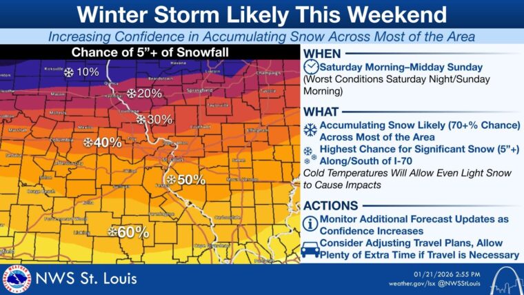
Snow accumulation is expected, likely starting on Saturday; current forecasts call for 4-6 inches, but the amount of snow that will fall and its exact timing is still uncertain due to fluctuations in the atmosphere.
This article covers how you can stay safe during this weekend’s major weather event, as well as specifics on what we know and what’s still uncertain with local cold temperatures and snow accumulation. We’ll also touch the nationwide impacts resulting from this storm system and some of the science behind the storm.
This article was written by WashU Weather, a team of student amateur meteorologists, using weather sources ranging from the National Weather Service St. Louis to scientific models and simulations. This article will be infrequently updated as the weekend approaches and forecasts increase in certainty. For more frequent updates, check out the WashU Weather Instagram.
Update 1: Friday, Jan. 23 at 10:30 a.m.
On Thursday at 1:15 p.m. CST, the National Weather Service issued a message upgrading Wednesday’s Winter Storm Watch to a Winter Storm Warning. This is a relatively common occurrence ahead of winter storms as forecast confidence rises. Anticipated snowfall accumulation totals have increased to 5-10 inches for the overall warning area — this number climbs to 6-12 inches in the St. Louis metro. Timing remains somewhat uncertain. In any case, expect significant travel impacts.
Unsurprisingly, the NWS has also issued a Cold Weather Advisory, warning of wind chills as low as -15 F (-26 C) over the weekend. No major changes here: stay indoors when possible and be sure to wear appropriate clothing if you must go outside.
Update 2: Friday, Jan. 23 at 2 p.m.
On Friday at 1:30 p.m. CST, the NWS updated the Winter Storm Warning to expressly forecast 6-12 inches of snow between late Friday night and 6 p.m. on Sunday. The warning states that “Travel could be very difficult to impossible.” That being said, St. Louis is on the northern side of this warning zone, and therefore total snow accumulation on the high side of that range is less likely.
How to stay safe
Extreme cold will be by far the most pressing safety threat going into the weekend. Temperatures will fall into the teens as snow pushes into the area, with overnight lows starting out in the single digits before dipping below zero late this weekend and early next week. 20-25 mph wind gusts will make wind chills much colder, almost certainly falling into the negatives even at times when temperatures themselves remain above zero. These conditions can pose significant health risks regardless of the climate you may be accustomed to at home. At 0 degrees (-17 C) with 15 mph winds, frostbite can set into exposed skin in just 30 minutes. Additionally, snowy conditions tend to increase the risk of hypothermia.
With this in mind, be sure to stay indoors when possible and bundle up properly for any activities that may require you to take a trek outside. Base layers or thermal underwear are crucial, as well as a good lightweight mid-layer and a heavy coat. Keep your face and ears covered — your nose, ears, and cheeks are among the body parts most susceptible to frostbite. If you don’t have a pair of snow boots, opt for lined boots or waterproof footwear along with thick socks. Keep your hands warm with a pair of gloves or mittens. Be aware that sidewalks may be slippery, and take short, slow steps if you encounter icy patches on the pavement.
While this applies more to apartment dwellers than to those in campus housing, remember to prevent pipe bursts by dripping your faucets, especially those closest to exterior walls. If you must drive, check the MoDOT Traveler Information Map to get a feel for road conditions. The City of St. Louis and cities throughout St. Louis County have already begun pretreating certain routes and will plow roads as necessary over the weekend, but remember that roads may still be slick, especially in freezing conditions.
Frigid cold
Successive arctic fronts will pass Thursday, bringing frigid air with them. A high pressure system originating in northern Alberta will then dive south into our area, bringing its cold air with it on Friday. This high pressure will persist over our area, leading to calm winds. Without wind to displace this frigid air, it will persist through early next week. Furthermore, any snow that falls throughout the day will absorb heat from the sun, keeping air temperatures dangerously cold for longer.
Specific temperatures to expect:
- Friday: 10-15 F (-12 to -9 C)
- Saturday: 0-15 F (-18 to -9 C)
- Sunday: 10-20 F (-12 to -7 C)
- *Monday: 0-20 F (-18 to -7 C)
- *Tuesday: 0-30 F (-18 to -1 C)
*Less certain forecast
Wind chills will make it feel another 10 to 20 degrees F (6-11 C) colder than the air temperature throughout the weekend. The coldest temperatures will be around sunrise on Saturday morning and Monday morning, with wind chills approaching the negative double-digits.
Accumulating snow
The southern boundaries of this storm aren’t likely to track far enough north to yield ice accumulation, so any precipitation in the St. Louis metro area should fall in the form of dry, fluffy snow, since the air driving this weekend’s intense cold holds so little moisture. Confidence also continues to increase in regards to accumulating snow — that is, this snow should stick and continue to build over the course of the storm.
In the St. Louis metro, snow will begin falling on Saturday, though when exactly the storm will hit during the day and its anticipated end time are unclear. For now, the best estimates indicate that snowfall will gradually build in the early afternoon before tapering off sometime Sunday morning.
Where St. Louis will fall within the general storm track still remains uncertain. As such, the numbers on just how much snow will accumulate are difficult to determine. The Winter Storm Watch recently issued by the National Weather Service (NWS) points to 4-6 inches within the watch area; however, that area covers most of southern Missouri, where snowfall totals could vary dramatically. The I-70 corridor has thus far been the commonly cited boundary for accumulating snow, but recent guidance suggests that the storm may track further north, which could make for higher snow totals in the St. Louis metro.
Predictive weather models diverge between a southerly path and a more northerly path; the latter would result in slightly less frigid temperatures and more snow for St. Louis, and models have begun to trend toward this setup recently. Compared to the Weather Prediction Center (WPC), accumulation forecasts by local stations in St. Louis have been trending on the higher side as well — anywhere from 4-7 inches as opposed to the WPC’s 2-4 inches.
Nationwide impacts
Thirty-seven states, from Arizona to Maine, will feel the impacts of the winter storm, but the specific impacts will be drastically different across the country.
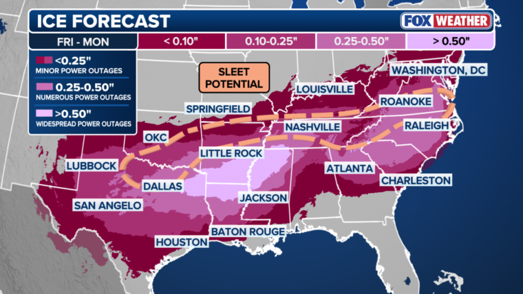
In the southeast, the biggest concern will be ice. Freezing rain caused by the mixing of warm and cold air will coat surfaces with up to half an inch or more of ice, which will snap tree branches and bring down power lines in some areas. The most significant ice accumulation will be around southern Arkansas, northern Mississippi, and the southern Appalachians, but a thin layer of ice may be present as far north as Maryland.
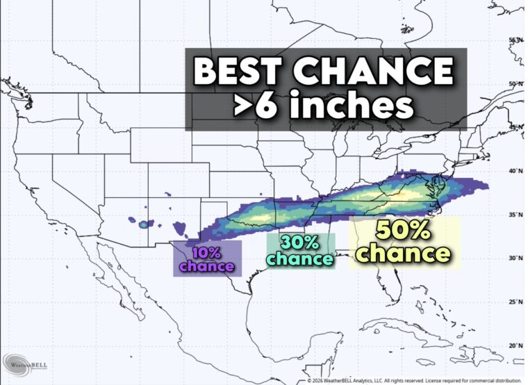
Snow will follow the path of the storm, from Oklahoma City to Washington, D.C. The range of heavy snow is likely to stay to our south. The areas of heaviest snow will most likely be in Oklahoma and the southern Appalachians, with a foot of accumulated snow possible in spots; as stated earlier, however, the exact path of snow is particularly sensitive to shifts in the fronts.
Brutally frigid cold is expected throughout the upper midwest. Parts of northern Minnesota may reach the negative 40s wind chill on Friday morning, with actual temperatures below -10 F (-23 C) for 36 consecutive hours. Frostbite in such conditions could occur in 10 minutes or less. Though the most extreme temperatures will be in the north, the arctic jet will bring abnormal cold throughout the country, with temperatures in the teens stretching as far south as central Texas.
The science behind the storm
Alright, so now that you know what is happening, let’s talk about why it’s happening.
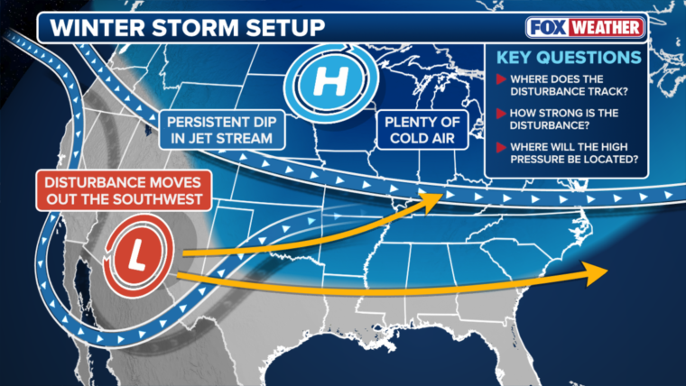
This weekend’s major winter storm will drive frigid impacts abnormally far south due to a dip in the jet stream, which will bring with it strong cold fronts and a high pressure system. This area of high pressure will meet a stationary front in the southeast United States with lots of moisture from the Gulf. The meeting of these systems will cause a substantial pressure gradient. Because cold air is denser than warm air, winds from the ocean will push the warmer air from the Gulf up, causing it to condense, giving rise to the large expected snow totals.
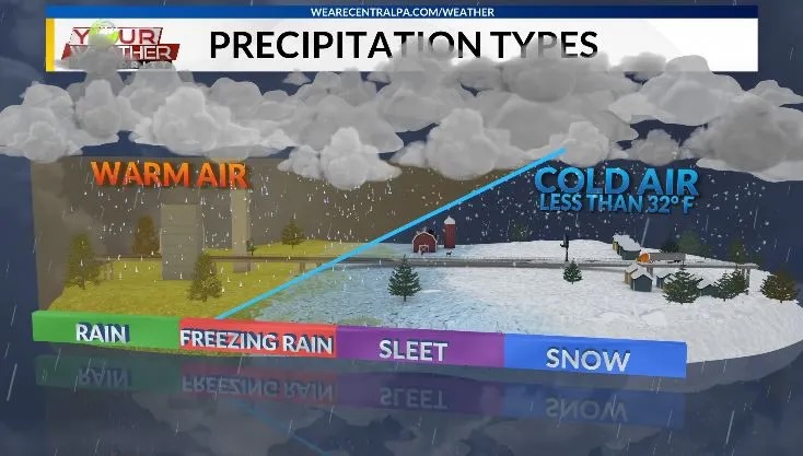
As the expected date of impact looms closer, confidence in the forecasts are improving, but uncertainties still remain. Small shifts in the track of the storm could have major implications on what locations see large amounts of snow. For example, if the system takes a more northerly track, heavier snow will be produced because this will allow the dry layer of air near the surface to moisten quickly. If the system moves farther south, this dry layer will take longer to erode, causing less snow to fall.
A winter storm watch was issued for St. Louis and the surrounding areas on Wednesday, Jan. 21.
Stay in Touch!
Get the latest and top news from StudentLife delivered to your inbox